The walk up Silver How via Faeryland
Silver How is the splendid hill to the west of Grasmere Lake. It is a good walk just in itself, giving great views over Grasmere Lake and Rydal Water. But as well as that, you can also use the elevation gained to go much further - along to Loughrigg, over into Langdale valley, or across a plateau over to the Langdale Pikes. You can walk for an hour or so, or all day, just as you choose and the weather permits! There are several ways to climb it - this way keeps you in sight of Grasmere Lake almost all the way.
Here's a map: some explanation will follow afterwards.

Go out of Lake View Country House, go up Lake View Drive and turn left on Stock Lane towards the centre of the village. Follow the road over the Rothay river bridge and turn left opposite the parish church down the Red Bank road. Go past the garden centre, the Grand Hotel, and several houses as the road winds until you get to Faeryland. Stop and look right - on the opposite side of the road to Faeryland you will see a wooden gate with footpath marker beside it.
The track starts with stones underfoot, and gradually becomes more like open country. After a short section closed in between two walls, you pass through a series of gates and come via some fields to the open fell. As you do this, the path turns left so as to end up parallel to the Red Bank road, above the houses scattered along it. Parts of this section are quite steep, but the path never becomes demanding!

After several gates the path levels out and goes at a shallow angle diagonally up the slope, following a wall on your left. As you climb, you see the views start to open out - Rydal Water appears behind Grasmere Lake, Helm Crag rises behind you, and between the two you can see across the valley to Tongue Gill, route of the Coast-to-Coast path. After a while you get to an obvious crossroads, where you need to decide on your plans for the rest of the walk.
The distance from Lake View Country House to this crossroads is just over a mile (just under 2 km) - about half an hour with some time for looking around and enjoying the view.
If you turn right you follow a steep but well-made path up onto Silver How. This brings your distance from the house up to nearly a mile and a half (nearly 2.5 km), but it is a slower section because of the gradient.
The remaining pictures assume that you have taken this track and climbed to the top of the ridge. As you reach the top of the track you will suddenly see the Langdale Pikes, with a series of other hills leading up to Scafell. From here you can wander all day across a broad upland plateau, dropping down eventually either into Langdale or Easedale, and perhaps visiting one of the several tarns up here - Stickle, Clodale or Easedale. Whichever way you go, you will find splendid views in all directions - providing that the weather is good - and can explore to your heart's content. Just make sure you have provisions and wet gear with you, as the weather can change suddenly, and you can end up a considerable distance from shelter.

Alternately, at the crossroad you can go straight ahead towards Chapel Stile - there are a few obvious paths down into the Langdale valley, as well as a great many places where the valley walls are too steep to consider as good routes. Both Chapel Stile and Elterwater have good cafes, and are handy springboards into the rest of the various branches of Langdale. At the upstream (west) end of Chapel Stile you will find the Langdale Boulders, with their enigmatic prehistoric markings still visible.

The final choice is to angle slightly left and continue following the stone wall. This will take you round to Loughrigg, via the long ridge at the south-eastern end of Silver How. After crossing the Red Bank road you can either climb Loughrigg for fine views down the length of Windermere, drop down to the stony beach at the southern end of Grasmere Lake, or keep in the middle and follow Loughrigg Terrace around towards Rydal Water.
Finally, whichever route you pick, you will want to make your way back to Lake View Country House, and enjoy a well-earned drink at The Good Sport!
Sketch views
Here are some annotated sketches of some of the views from Silver How. Actual views will look a little different as the seasons change.
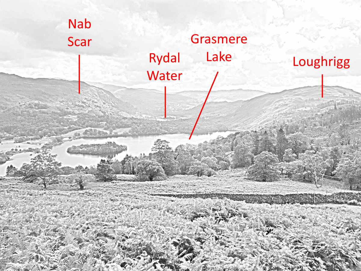
Grasmere Lake and Rydal
This view, which expands as you climb up from the treeline onto the fells, shows off Grasmere and Rydal lakes from an angle that not many people get to see.
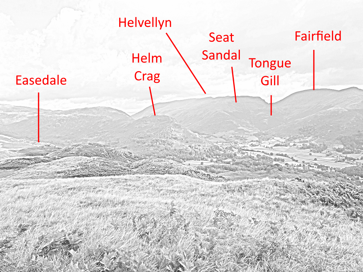
Looking roughly north
The skyline here is defined by the long north-to-south ridge containing Helvellyn and Fairfield. The coast-to-coast trail also features prominently - walkers come down Easedale and then leave up beside Tongue Gill to cross the Helvellyn Ridge at Grisedale Tarn, between Dollywagon and Fairfield.
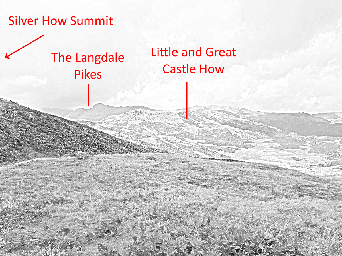
Looking roughly west
The westward view shows off the profile of the Langdale Pikes, which will become very familiar if you walk in this area for long. Also in this direction you can see some of the peaks clustering around Scafell, including Crinkle Crags and Bow Fell. Between you and these peaks, a broad plateau invites you to explore the area.
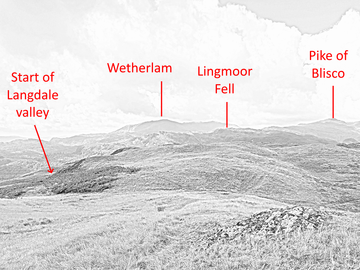
Looking roughly south-west
The Langdale valley is in this direction, but largely hidden from sight except at its eastern end. Lingmoor is a long ridge - well worth exploring in its own right - which divides Great and Little Langdale valleys. The rather stern north face of Wetherlam blocks you from seeing the Old Man of Coniston. If you climb higher along the ridge, you will see glimpses of Coniston Water and Esthwaite Water.
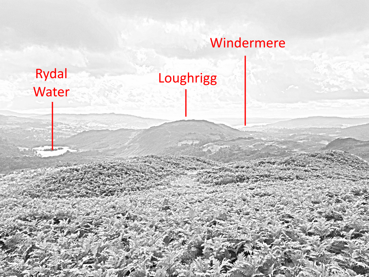
Looking roughly south-east
In this direction, Loughrigg blocks the Ambleside end of Windermere, but you can see this lake as it extends to the south. On a clear day, you can see Morecambe Bay beyond the last of the Lake District hills.